
|
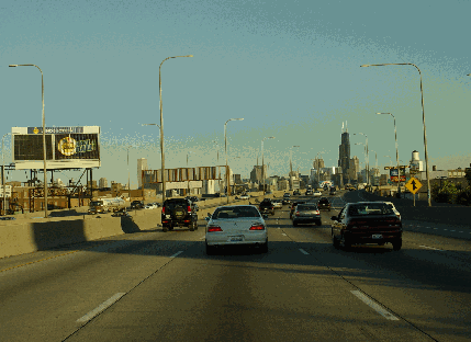
This 2004 photo shows the eastbound local lanes of the Kennedy Expressway (I-90 / I-94) at EXIT 48A (Armitage Avenue). In the median is the reversible two-lane express roadway; the CTA Blue Line departs the expressway median at EXIT 45B (Kimball Avenue). (Photo by Jim K. Georges.) |
||

|
EARLY PLANS FOR THE "NORTHWEST" EXPRESSWAY: In 1927, the Chicago Plan Commission announced plans for a network of "superhighways" emanating from the Loop to the south (current route of the Dan Ryan Expressway), southwest (Stevenson Expressway), west (Eisenhower Expressway), and northwest (Kennedy Expressway), as well as a lakefront route (Lake Shore Drive). A north-south cross-town route on Chicago's West Side was added later. The initial alignment for the proposed northwest route, known first as the Pioneer Speedway and eventually the Northwest Expressway, actually was born four years earlier as planned elevated highway abutting the existing embankment of the Chicago & Northwestern Railway. |
||
|
"The downtown terminal was to be a plaza created by widening Canal Street from Monroe to Madison. At the center of the plaza an inclined roadway 50 foot wide was to rise from Monroe to Madison and continue North on Canal Street at an upper level over the Chicago and Northwestern Railroad on a direct north south line to Chicago Avenue." The road was to extend northwest nearly 10 miles passing over and under the railroad until it reached Northwest Highway and Parkside Street. |
||
|
The Cook County Board announced a more detailed follow-up proposal in 1939. The $30 million Northwest Expressway was to have eight lanes (four in each direction), and was to extend 10 miles northwest from the Chicago Loop on air rights over the Chicago & Northwestern Railway. Connections were to have been provided with Lower Wacker Drive and a new crosstown link with Lake Shore Drive along Ontario and Ohio streets. According to the Chicago Tribune, the expressway was advocated as a means to prevent slums from developing on the West Side and prevent the northward movement of the central business district. |
||
|
In 1940, the county presented an alternative proposal that would have routed the expressway along Clybourn Avenue and Elston Avenue, instead of the Chicago & Northwestern Railway alignment; part of this alignment was east of the North Branch of the Chicago River. Ultimately, the City of Chicago decided upon the original Chicago & Northwestern Railway alignment as it was not only served a denser population west of the North Branch, but also provided the most direct route to the proposed airport at Douglas Field (now O'Hare Airport, which the City of Chicago had purchased from Douglas Aircraft in 1946). However, the onset of World War II delayed all of Cook County's expressway plans. |
||
|
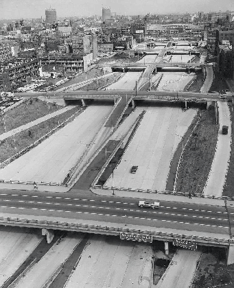
The John F. Kennedy Expressway--then known as the Northwest Expressway--awaits the opening of traffic in this 1960 photos. (Photo by Cook County Board of Commissioners.) |
||
|
"I don't like tolls. Nobody does. But faced with a choice of toll roads or no roads, I'll take tolls." - Cook County Board President William Erickson, in a 1952 interview with the Chicago Tribune |
||
|
SHORT-LIVED PLANS FOR A TOLL ROAD: With plans for the Northeast Expressway stalled, and 32,000 vehicles per day (AADT) streaming out of the southern terminus of the just-completed Edens Expressway without a controlled-access outlet, Cook County officials offered a plan in 1952 to make the expressway a toll road. The toll road proposal meshed with state plans to develop a Northwest Tollway to the Illinois-Wisconsin border, as well as plans by Wisconsin officials to build a turnpike through Madison toward the Minneapolis-St. Paul area. |
||
|
Citing a chronic lack of funding, the Cook County Board transferred seven miles of the Northwest Expressway right-of-way to the Illinois State Toll Highway Commission (ISTHC) in December 1954. The expressway was to become part of the Northwest Tollway. By the time of the transfer, the county had acquired 95% of the right-of-way. The county retained the remaining seven-mile-long section from the "Edens Junction" (Cicero Avenue / proposed Edens Expressway) connection east to the Chicago Loop. |
||
|
At the time of the transfer, the cost of the expressway was estimated at $30 million, which was to be paid by a county-sponsored $245 million bond issue, and by June 1956, supplemented in part by 90 percent Federal financing from the Interstate highway program. The portion of the Northwest Expressway from the "Montrose Split"--the portion that remained under county jurisdiction--was to be financed with Interstate highway funds as part of the newly designated I-94, while the portion from the Montrose Split to O'Hare Airport--the segment that had been under Tollway Commission jurisdiction--was to be built with bond issue funds as part of the state highway system, and thus was given the designation IL 194. |
||


|
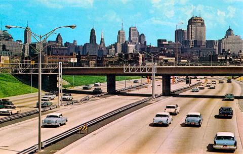
This circa 1961 postcard shows the newly opened Kennedy Expressway--then known as the Northwest Expressway--with the overhead sign gantries erected without signs. (Postcard supplied by John Chuckman.) |
||
|
DESIGNING THE EXPRESSWAY WITH ROOM FOR THE FUTURE: The Northwest Expressway was designed with three distinct sections as follows: |
||
|
BUILDING THE EXPRESSWAY: Construction of the Northwest Expressway began in 1955 in the area west of the Chicago Loop, where construction crews began demolition and created detours for east-west streets to make way for the grade separations and connecting entrance and exit ramps. Right-of-way contracts for the remainder of the expressway were awarded in 1956 and 1957. Before crews performed any road construction, underground gas, electric, and sewer lines had to be relocated and rebuilt. About 350,000 feet of sewer pipes had to be replaced, and at the Mayfair sewer pumping station near the "Montrose Split," an underground bridge for local sewer pipes had to be built over the main pipes serving the pumping station; earthen fill was placed over this underground bridge. The most challenging part of building the expressway involved its adjacency to Chicago and Northwestern Railroad commuter line. The expressway was built over three railroad yards--the viaduct alone over the rail yards cost $20 million--as well as over and under the adjacent three-track commuter rail line. The proximity of the new expressway required numerous temporary track relocations and the permanent relocation of one line. At Jefferson Park, a tri-level grade separation had to be built with the expressway (and future rapid transit right-of-way) on the lowest level, Milwaukee Avenue on the middle level, and the Chicago and Northwestern commuter lines on the highest level. Despite the potential for disruption, engineers kept Milwaukee Avenue open to traffic during construction and built temporary tracks for the Chicago and Northwestern lines around the site. The new elevated structure for the railroad featured curved steel girders that were 127 feet long; these girders had to be carried by three articulated flatbed railroad cars from the fabrication site in Hammond, Indiana. Perhaps the most contentious right-of-way dispute involved the parishioners and politically connected pastor of St. Stanislaus Kostka Church in Chicago's Noble Square neighborhood. The pastor was involved in the negotiations with the state and even was active in the design process, and as a result of these negotiations, the parish succeeded in getting the state to move the expressway such that it would miss the rectory building by 10 feet. Enabling this move required the Illinois State Legislature to approve the use of highway funds to not only move the expressway right-of-way east, but also purchase a substitute right-of-way to move the adjacent Chicago and Northwestern tracks. This resulted in a gentle curve of the adjacent tracks through Noble Square. In order to squeeze as much expressway and future rapid transit into the right-of-way as possible, engineers decided to leave a steep slope between the depressed expressway and the surrounding neighborhoods rather than build less attractive retaining walls. Because the slope was too steep to be mowed, landscape architects planted trees and other plants along the right-of-way. This landscaping program continues to this day. Construction was about half-completed by 1958, but the nationwide recession threatened to stop construction of the state's new Interstate program. Although Cook County had its own bond issue money to finance construction--for its part, the county awarded $18 million in contracts in a single day that year--this was not the case for either the state or the City of Chicago. Faced with potential construction stoppage, the state launched an Interstate highway bond-issue plan that would permit a smoother flow of Federal highway funds. In this scheme, the state-financed bonds would provide the funding backstop if there was a shortage of Federal funds, while the bonds would be paid down once Federal funds were in place. |
||
|
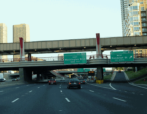
This 1990 photo shows the eastbound Kennedy Expressway (I-90 / I-94) approaching EXIT 51B (Randolph Street). The reversible express lanes on the left are about to end at their Ohio Street terminus. Major reconstruction of the expressway would not begin for another two years. (Photo by Steven Martin.) |
||
|
OPENING IN STAGES: The first 0.5-mile-long section of the Northwest Expressway--the section west of the Chicago Loop from the Congress Parkway / Eisenhower Expressway west (north) to Washington Boulevard--was opened to traffic on December 4, 1958. A follow-up section--only 0.2 mile long--extended from Washington Boulevard west (north) to Lake Street and was opened to traffic on September 30, 1959. Both short sections were built by the city, but because they were part of I-94, the city received 90% of its construction costs back from the Federal government. |
||
|
Cook County did its part by opening a 4.2-mile-long section from the Northwest Tollway (now I-90) and the O'Hare Extension (now I-190) east to Foster Avenue on December 15, 1959. The new section provided ramps to the northbound Tri-State Tollway (I-294) and from the southbound Tri-State, but did not provide any direct connection to O'Hare Airport, nor where there any intermediate entrance and exit ramps available when the expressway was opened. Furthermore, there was no lighting or landscaping, and there were only temporary guide signs. This follow-up work, along with the direct link to O'Hare and the missing connections to the southbound Tri-State and from the northbound Tri-State, was completed by September 1960. Although the county built this section, it was designated by the state as part of IL 194; however, the county was reimbursed for 50% of its construction costs by the Federal government, as this section originally was not part of the Interstate system. |
||
|
This 2007 photo shows the westbound Kennedy Expressway (I-90 / I-94) at the split for the Edens Expressway (I-94). In the median are the reversible two-lane express roadway and the CTA Blue Line. (Photo by Steve Anderson.) |
||
|
REBUILDING THE KENNEDY: The Kennedy Expressway had its first major repair to remedy faltering pavement in the summer of 1971; this was part of a $16 million project to resurface the Kennedy and Dan Ryan expressways. The lanes were rebuilt with a 10-inch-deep continuously reinforced concrete pavement, the existing sub-base was replaced with a four-inch-deep asphalt sub-base, and new deformed steel reinforcement bars were added. At least one lane was closed in each direction during the length of the project. |
||
|
In 1992, work began on a more comprehensive $450 million, three-year project to rebuild the 7.5 miles of the Kennedy Expressway from the "Edens Junction" east to "Hubbard's Cave," the name given to the long underpass just west of the Loop. The project rebuilt all three carriageways of the expressway, with the reversible lane closed in the 1992 construction season, the eastbound lanes in 1993, and the westbound lanes in 1994. Particular attention was paid to providing direct access between the reversible lanes and the Kennedy / Edens expressways at the north end, such as vehicles no longer had to leave across several lanes of traffic to reach the eastbound reversible lanes at the "Edens Junction." Similarly, separate direct access was provided at the Ohio Street Extension for the westbound reversible lanes. New steel mesh barriers and automated breakaway gates were installed to prevent wrong-way vehicles from entering the reversible lanes, replacing the six workers who had to cross busy expressway lanes to install and remove barriers manually. |
||
|
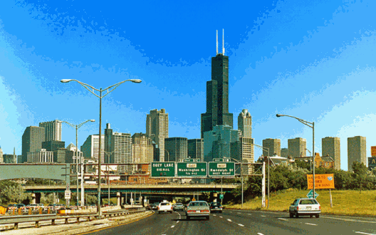
This 2005 photo shows the eastbound Kennedy Expressway (I-90 / I-94) at EXIT 51B (Randolph Street) just west of the Chicago Loop. This section originally was built with nine exit ramps serving the Loop, but during reconstruction, four ramps were removed at Washington Boulevard (left entrances to eastbound and westbound Kennedy) and Monroe Street (left entrances to eastbound and westbound Kennedy) (Photo by Jim K. Georges.) |
||
|
SOURCES: "Board Approves 'L' Highway to West Side" by Hal Foust, Chicago Tribune (9/29/1939); "West of River Superhighway Favored by City," Chicago Tribune (10/15/1945); "Lack of Cash Blocks Work on Super-Road" by Hal Foust, Chicago Tribune (7/25/1950); "Erickson Urges Toll Roads in Cook County" by Hal Foust, Chicago Tribune (11/24/1952); "Plan Seven Miles of Toll Road as Freeway," Chicago Tribune (03/24/1956); "Toll-Free Road to O'Hare OK'd by Commission," Chicago Tribune (7/14/1956); "Big Northwest Expressway To Open in 2½ Years," Chicago Tribune (4/29/1957); "1959 May Find Half of Road Open to O'Hare" by Hal Foust, Chicago Tribune (4/02/1958); "Expect To Open Freeway East of O'Hare in 1959," Chicago Tribune (9/12/1958); "Northwest Thruway Opens Today, Stress Safety" by Hal Foust, Chicago Tribune (11/05/1960); "90,000 Autos a Day Using Northwest Thruway" by Hal Foust, Chicago Tribune (11/22/1960); ); "Northwest Expressway," Cook County Board of Commissioners (1962); "Open Two Extra Lanes Today in Northwest Thruway" by Hal Foust, Chicago Tribune (1/21/1961); "Kennedy Redux: How Three Years, $450 Million Were Spent on the Road" by Mary Beth Sammons, Chicago Tribune (10/30/1994); "Safety Work Actually Adds Danger to Kennedy Expressway Ramps" by Jon Hilkevitch, Chicago Tribune (8/24/2009); Chicago-L.org; Illinois Department of Transportation; Brandon Gorte; Andy Plummer; Bill Stremmel. |
||

|
KENNEDY EXPRESSWAY LINKS: |
||
|
KENNEDY EXPRESSWAY VIDEO LINKS: |
||
|
KENNEDY EXPRESSWAY CURRENT CONDITIONS: |
||

|
THE EXITS OF METRO CHICAGO: |
||
|
Back to The Roads of Metro Chicago home page. |
||
|
Site contents © by Eastern Roads. This is not an official site run by a government agency. Recommendations provided on this site are strictly those of the author and contributors, not of any government or corporate entity. |
||